Redditor Maps Location of Chicago Speed Cameras

By Gilbert Falso :: 7:53 PM
Chicago Mayor Rahm Emanuel announced late last week that the city would be stepping up traffic enforcement in certain areas with the use of speed cameras.
The cameras, mostly located near schools and parks, will be unmanned, and will photograph a driver and their car if they violate the speed limit on that particular stretch of road.
Although some of the possible locations had been announced earlier this year, Emanuel confirmed those locations along with an additional 38 to bring the grand total of Chicago speed cameras to 50.
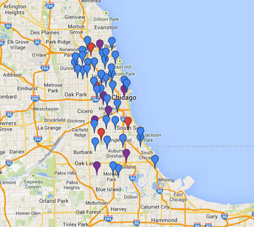
An enterprising Reddit user, “5-4-3-2-1-bang,” spent part of this Labor Day weekend putting together a map of the location of the speed cameras with Google Maps. The map was then posted to the site’s sub-Reddit for the city of Chicago.
The map is color-coded, with red pins meaning the cameras are already up and taking pictures, purple pins meaning that the cameras should be activated by the end of September, and blue pins indicate that cameras are planned by the end of the calendar year.
A static image of the map is below, with a link to the interactive map on the Google Map site.

View the interactive map.